Showing posts with label street views. Show all posts
Showing posts with label street views. Show all posts
Wednesday, October 19, 2022
Friday, March 11, 2022
Recent commissions
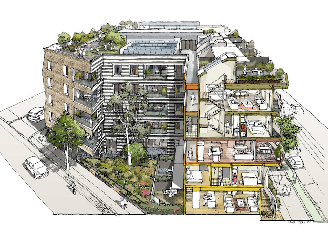
This series of drawings shows a proposed residential development in North Melbourne by MAB Corporation. Felt tip pen and digital colouring based on 3D renders by McBride Charles Ryan architects.
Thursday, January 13, 2022
Service Street park
Prepared for Moreland Council this illustration shows a view of a proposed park in Coburg. Felt tip pen drawing and digital colouring.
Saturday, November 6, 2021
Aerial view
A commission for a Melbourne developer this drawing was done with felt tip pen and digital colour. I used a supplied 3D CAD view and aerial imaging.
Friday, October 1, 2021
Recent commission
Wednesday, February 17, 2021
Tuesday, December 8, 2020
Wednesday, May 6, 2020
Monday, December 9, 2019
Boronia illustrations
A series of illustrations prepared for the City of Knox, published in the Boronia Renewal Strategy 2019.
Labels:
Architecture,
Landscape,
People,
street views,
Urban Design
Tuesday, September 17, 2019
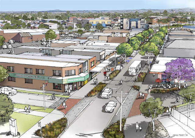
Main Street aerial view
A drawing showing road changes and new trees in a Victorian town. I had an aerial photo as reference for this one. Felt tip pen and digital colouring.
Labels:
Architecture,
Landscape,
street views,
Urban Design
Recent park illustrations
A great project where the inner city council is purchasing industrial sites to create small parks where residential density is increasing.
Saturday, May 25, 2019
Monday, October 22, 2018
Recent street view
A recent illustration commission, showing a raised eye viewpoint of proposed road and landscaping scheme and urban design. Hand drawn linework with digital colouring using Affinity Photo.
Monday, August 13, 2018
Thursday, May 31, 2018
Recent urban design illustrations
These recent illustrations were prepared for a Melbourne municipal council for their urban design framework report. They show how the proposed planning guidelines could be implemented with development in the future.
I used a 3D massing model to set up the views and precedent images as reference for the architectural styles. Hand drawn pen drawings were scanned and digitally coloured using Affinity Photo.
 |
| view 1 |
 |
| view 1 existing |
 |
| view 2 |
 |
| view 2 existing |
 |
| view 3 |
 |
| view 3 existing |
Thursday, April 26, 2018
Lens length and field of view
I recently came across the impressive photo "California Street, San
Francisco 1964" by Todd Walker and was reminded how important the choice
of camera lens when composing a view.
In setting up my street-scape illustrations I often use Google Street View or Google Earth Pro* as references. While Google Street View is terrific at showing the context information I need, there are limits to how 'realistic' the view feels compared to the experience of being there. As I am not a photographer I think this is due to the short lens used to capture wide views of Street View. Mobile phone lenses are also quite short I believe (30mm equivalent).
The images above all show the same view of California Street with the reference building on the right side of the street (noted with an amber dot) shown at the same scale. The apparent different height of the hill beyond in each image shows how tricky it can be to correctly scale the background in a streetscape.
I often set up the context for my illustrations by creating a very basic SketchUp 3D model to get the perspective right. When setting up a SketchUp scene I need to adjust the camera Field of View to export an image that will best fit the composition and focus of my illustration.
*(I use the older non-online version of Google Earth Pro which has the ability to adjust the Field of View)
Thursday, April 5, 2018
Subscribe to:
Posts (Atom)


